Polar co-ordinates achieve the same result i.e. the description of the position of a point. The main difference is that polar co-ordinates use one distance and one angle to describe the position of a point rather than the two distances in the Cartesian system. The distance and angle measurements are made relative to an origin. This results in a point description which looks like this 34.897<30 where the first figure is the distance (in drawing units) and the second is the angle.
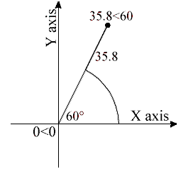
Notice that the separator in the case of polar co-ordinates is the "less than" mathematical symbol. If you look at your keyboard you will see that this symbol is typed by using Shift and comma.
AutoCAD angles start at 3 o'clock (i.e. along the positive portion of the X axis) and increase in an anti-clockwise direction. You can specify negative angles if you need to define an angle in a clockwise direction although this is not really necessary because angles are circular, hence an angular value of -30 degrees will give the same result as an angular value of 330 degrees (there are 360 degrees in a full circle).
No comments:
Post a Comment